


WORDS: LONNEKE KEFALAS IMAGES: MATT HULL PHOTOGRAPHY, LONNEKE KEFALAS
Run Larapinta: Malbunka long course, 21-24 April 2021
Run Larapinta! It was a long time in the making and it went by too fast!
We registered in November 2019 for the August 2020 event, which, due to COVID-19, had to be postponed to April 2021.
It was well worth the wait! What an amazing four days of running in beautiful scenery on rugged terrain (brutal at times), with a group of like-minded and wonderful people, and the fantastic organisers, Rapid Ascent.
I am writing this a few weeks after the event, and am still buzzing and wish I could do it all over again.
I wanted an epic adventure for my 40th birthday and that sure is what I got – even though it ended up being for my 41st with the postponement!
John, my running friend and training partner at Runlab, planted the seed for Larapinta in 2019, and our friend Sandra, also from Runlab, decided to join in as well. This made for a great lead-up with many training runs together and keeping each other motivated, especially when the dreaded news came a few weeks before the original event date in August 2020 that it had to be postponed eight months into the future, in another calendar year!
The descriptions below of the trails, terrain and atmosphere do not do the experience justice. I have found it is impossible to describe what the Larapinta Trail is like, as well as the vibe of embarking on such an adventure with fellow runners and the camaraderie that comes with it. Even photos do not look anything like what I saw underneath my feet and looking up ahead. The Northern Territory really is magic!
Pre-race
The organisers planned a pre-race gathering on the evening before the first run to meet the crew and our fellow runners and ask any questions that we may still have had – even though the runner’s guide covered a lot. This was a great start to race week!
Day 1
- Distance: 20.5km
- Highlight: Sunset colours
- Grateful for: Good running light and not encountering any snakes
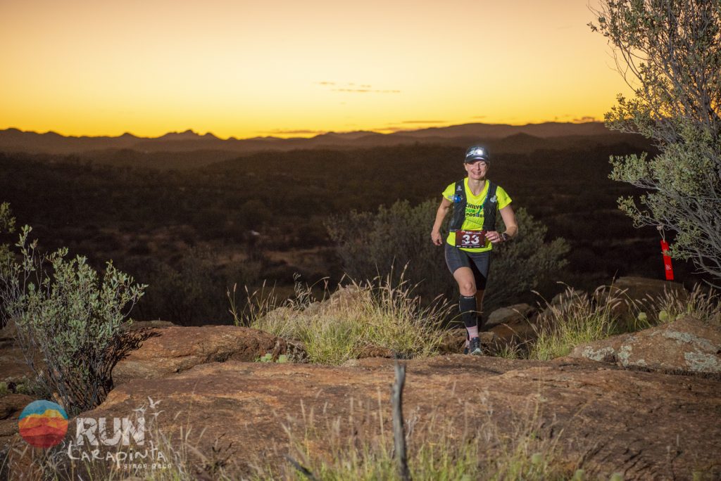
Today, the event formally kicks off and the race jitters are real! There is the race check-in that includes a mandatory gear sign off and then the event opening and briefing. The first run is a sunset run where we’ll start in the light, run into the sunset and finish in the dark. I’m excited, albeit a little worried, about running in the dark, as I don’t do a lot of it and don’t want to misstep and roll my ankle – ending it all before it ever really began!
We start from the Alice Springs Botanic Gardens, and I soon need to drink something because the dry heat and air dry out your mouth like nothing I’ve experienced before. We soon hit the trail, which has fun switchbacks and beautiful scenery with the sun slowly starting to set, until eventually you just have to stop to take it all in and try to capture its magic in a photo. While today’s course is the shortest and easiest of the four days with only 200 metres elevation, and having been told that it is a road run compared to what’s to come, it is still not easy. Running in the dark for me goes from pretty scary because I can only see the small part my light can shine on to OK, and then back to scary again. Reaching the first finish line of another three to come is a great feeling because I survived the first run, which takes a few of the nerves away, I didn’t roll my ankle and didn’t see any snakes, although one of the other runners saw three!
Day 2
- Distance: 41km
- Highlight: Every second on this brutal but brilliant course and the chats with other runners
- Grateful for: Running poles and having a navigation buddy through the hardest part of the dry river bed
Today is the big day; the one I’m most nervous about because it is going to be hard! Looking at previous results, I anticipate I’ll be out there for at least as long as my Ultra-Trail Australia 50k time.
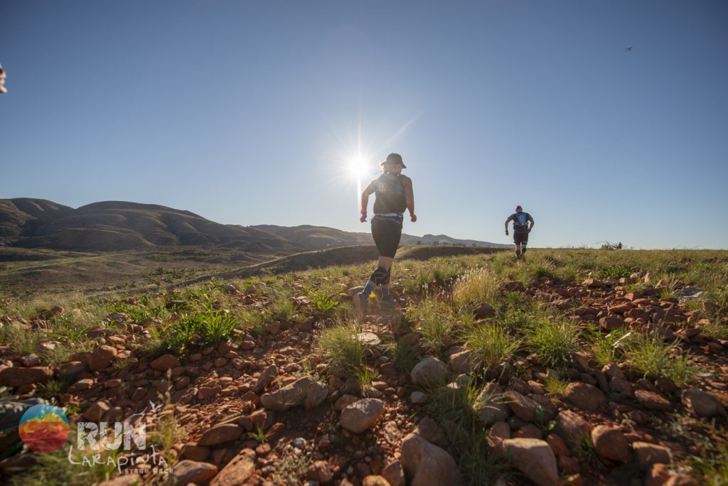
We start from the beautiful Simpsons Gap. The first things I notice are the colours of the rising sun, high grass and a vast amount of flowers, thanks to the recent rain that has turned the red centre into a lush green.
The first rule I make is that if I can’t see the ground because of the high grass, I walk, because you can’t see what is underneath and it is all too easy here to land awkwardly on one of the many rocks on the path and roll an ankle, ending my adventure way too soon.
We run opposite the mountain ranges and I wonder if we will soon be climbing one of those impressive-looking peaks.
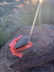
The first few kilometres are a bit challenging to navigate – a fact confirmed by the pink flagging tape attached to a rock on the ground, indicating which way to go. A few kilometres in, I get into a flow with nice chats with fellow runners. I join up with another group a little later through Jay Creek, where we lose the path and work as a team to find it back. We also find fruit growing from the tiniest of plants on the sand that look like watermelons (Lucy Bartholomew, did you plant those when you ran the full trail solo a few weeks before the event?).
Then we are close to the 28km aid station that is calling us after a tricky downhill climb and I pull in there after 4.5 hours of running and “only” 13km to go. I eat some deliciously juicy fruit, fill up with the mandatory 3-litre hydration, apply suncream, encourage a runner who fell and is not sure whether to keep going or not, and am then back on my way.
Not that it was easy to get there, but I do wonder how long the remaining 13km can still take, even though I know this is where the hard bit really starts.
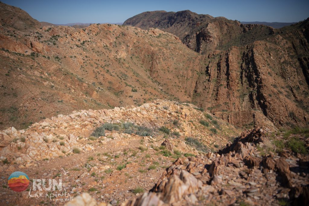
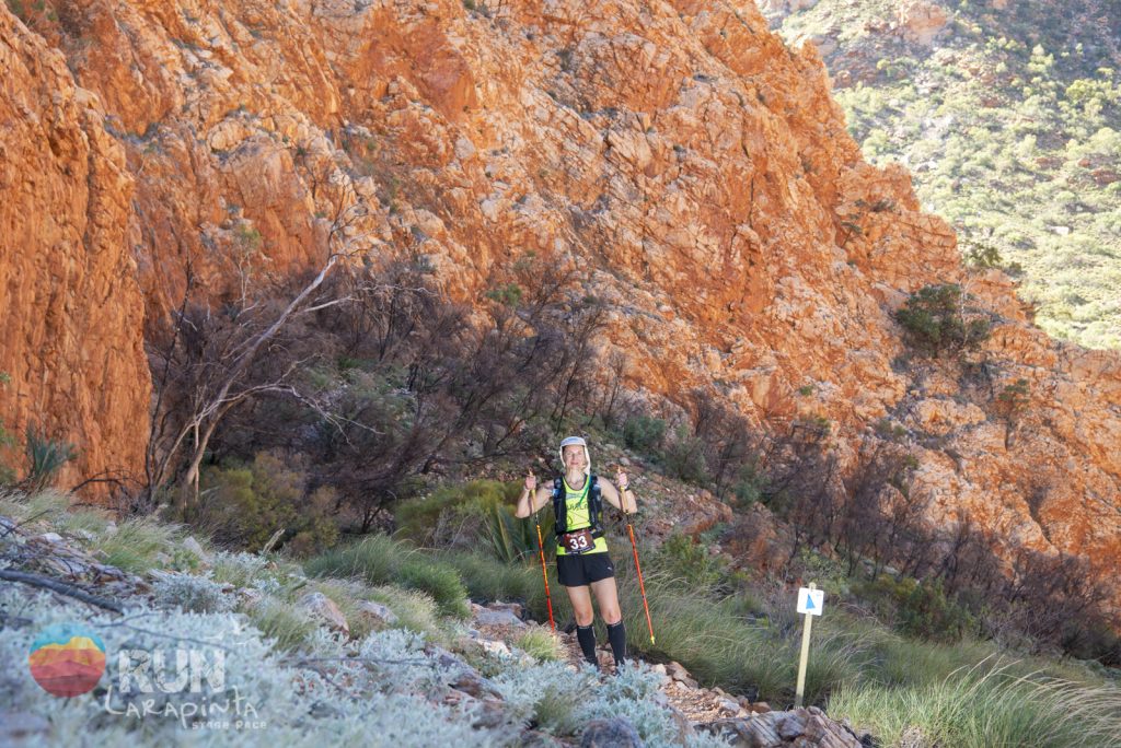
Soon enough, the hard parts come – and keep coming! We start with a steep climb up the hill – similar to those we saw at the start, which seem to go on and on. Then there is the sign for the High Route that is in the course description. This is the only sign over the four days that has a time indication on it: 2.5 hours for 4km, which makes sense for hikers, I think – it must be hard terrain and walking it would slow the pace to a trickle, but surely it would be faster for a mid-pack runner.
 Well, it hardly is. I don’t know how long exactly that section took, but it wouldn’t have been too far off. The terrain becomes incredibly hard. The downs are really steep to the point I don’t think I would have made it without being able to put my poles down first and lean in to get down on that step, although it is not really a step, because you have to find where to best go down and place your feet as it is not carved into the trail. This is where I meet a fellow participant who is a great navigator. Together, we work our way through the dry river bed that is incredibly rocky – I’m talking big boulders and thousands of them that just go on and on and on. There are places where we are not sure where to go next because there is no path and there are no Larapinta markers nor any pink ribbon, or at least not at first sight, but then when looking again intently, we do see it. At a certain point, it feels like we are bouldering or half-rock climbing onto and then through a little rock gap or saddle. Who knows at which kilometre mark or what hour we are into the run because I’m so immersed in finding my way and working out how to get on or through or around the obstacles that Larapinta throws our way. And it just keeps going on!
Then there is the photographer. That must mean we are getting close because he must have come here on foot (there is no other way!). But no, there is more in store: more steps down and up, but at least they are carved-out steps, although still tricky – especially on spent legs. Finally, we reach the walkway of Standley Chasm and are super close to the finish. I can run this bit, albeit slow. With 8 hours, 37 minutes on the clock, I sit down at the finish line and smile because I feel invincible from this run, which is the hardest and longest (time, not distance) I have ever done and I loved every second of it! Then it is time to cheer in the other runners!
So, how long can 13km take? Well, on the Larapinta Trail, it took 4 hours, 3 litres of water and a lot of grit (I finish with over 500ml left but others ran out and took water from one of the crew, who walked to the photographer to supply water to those who had run out). My phrase of the day to describe this section is “brutal but brilliant”!
A few facts:
- 3 hospitalisations, numerous falls, countless near-falls.
- One of the runners was convinced halfway through the tough 13km section that this was one of those races that did not have an end!
- If there was a Strava segment on any part of this section of the course, it would be called, “Mate, where’s the path?”
- This constitutes my longest everything running wise (duration, climb, time using poles, time to cover 10km, 5km, 1km and so on).
- National Parks asked the organisers to leave the pink flagging tape for race day to aid hikers in navigating that section (and yes, these hikers are incredible because they do this brutal section with big backpacks containing everything, including a tent, over the course of 2-3 weeks in which they cover the entire trail).
- The winning times on this course are just phenomenal!
- First female: 5h29m22s
- First male: 5h27m18s
- Record holders: Female – Hanny Allston 4h53m34s; Male – Felix Weber 4h23m59s
Day 3
- Distance: 32.5km
- Highlight: Body feeling good after 2 days of running
- Grateful for: Family back home in the Netherlands following along
Today’s and tomorrow’s courses are new in the six-year history of the event because Glen Helen Lodge is closed as a result of the drop in (international) tourists due to COVID-19, so we can’t run on that part of the Larapinta Trail.
We start with a long section of mostly flat fire trail with views of the ranges on both sides. It is great to get into a rhythm after a lot of non-runnable terrain yesterday. But after about 10km, I’m ready for a change of terrain, which comes at the 14km mark at the Birthday Creek waterhole. We then start to climb the ridges of the ranges and make our way to Brinkley’s Bluff, a challenging and zig-zagging 550 metres of elevation in just 3km. It is a bit of a shock to see faster runners ahead in the distance quite a way up and in places where you need to use your hands, too, but the views are amazing!
I push on the hills but am not using poles because there are runnable sections in between. On the bluff, the path is mostly rocks, very technical and difficult, and despite my legs feeling good (yesterdays’ massage really helped), I can’t push myself too much without the risk of rolling an ankle, so I take it a bit easy here. The navigation is tricky and I’m happy I’m with others as we find our way, especially when the “path” is hiding behind a large rock. We are more rock climbing than hiking or running as we are high on a little ridge with a drop-off – just wow!
On the bluff, I can hear the wind before it comes, which I find a cool, surprising fact of being this high in nature. We continue on the bluff for several kilometres and eventually come to a dry river bed where we find the Rapid Ascent arrows – always a good sign, as it means we’re close to the finish. However, the dry river bed goes on for longer than expected and there is still a little climb up and then one last down to make our way to the finish (a few kilometres more than advertised) at Standley Chasm again, but the other side this time.
There, I learn that the overall winner of today’s course is Erika Lori, who beat the first male by 12 minutes – way to go! And she also takes out the overall event win, beating the first male in second place by a good 10 minutes. Nice one, Erika (I hope your feet recovered well afterwards – they looked quite beaten up)!
Day 4
- Distance: 34km
- Highlight: That finish line feeling!
- Grateful for: Husband, friends and fellow runners at the finish!
We start from Ochre Pits today, which is another stunning location and the budgerigars think so, too, so we get to admire these colourful birds as we make our way to the start line.
The landscape and scenery are again so different to previous days. I find it extraordinary that the West MacDonnell Ranges are so varied over the length they cover.
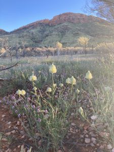 The first few kilometres are on uphill rocky terrain with flowers on either side. Then we have a long section going through waist-high grass on a flowy single-track before heading up for a big climb to a beautiful lookout, where we have our photo taken and get some encouragement. Then we head on again over the rocky path, where Sandra and I take a selfie as we meet halfway on the way out/back.
I pushed hard on the climb and kept pushing afterwards because it is the last day and there is nothing I need to save my legs for anymore (although I do decide today that I might as well do UTA50, given that I have pulled up so well after every day so far).
After running on the bluff for several kilometres, playing another game of “find the path”, we start to make our way down to the aid station at Serpentine Gorge, which is a fantastic bit of downhill that I really enjoy and where I feel like I can just let go.
Even though I don’t know it yet at the aid station, my emotions must be running high already because I forget to fill up with water/electrolytes and apply suncream. So, I do that 1km afterwards on the go because I feel good and don’t want to stop.
Then, I run past the sign with the Ellery Creek finish location and the countdown begins, which makes me both elated and sad that this epic adventure is coming to an end! Soon, the first single-digit marker is in sight and then the countdown is on to the 5km parkrun distance, which takes us over more rocky climbs of dark brown rock with white lines through it. Again, we have to try to find the path (I’m not so good at it, and follow a fellow participant, who easily hops along and finds the path). With only 3km to go, we are on nice, runnable terrain again. Upon coming across some fellow runners, we let out a few celebratory woo-hoos and I ask whether it is too soon to cry, as I am trying to keep things together as I near the finish line!
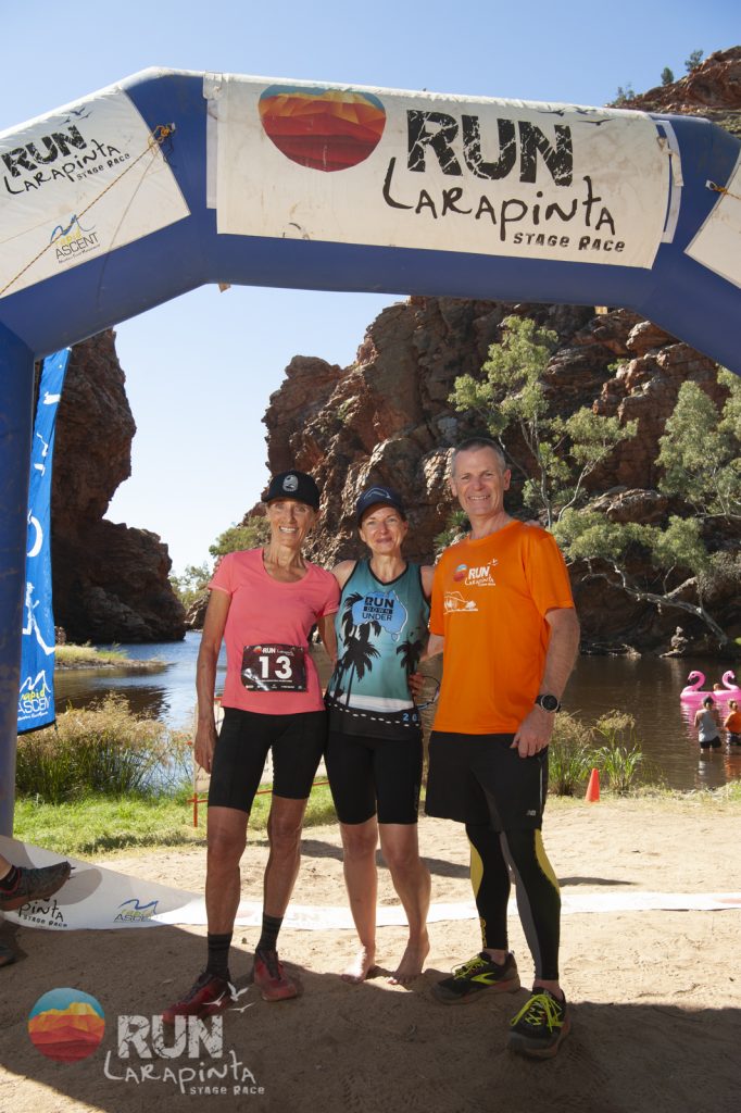
There is one last dry river bed (of course) and the way to the finishing chute, and finally the finish itself, where my husband and the refreshing waterhole are waiting, as well as more tears! My friend John, who did the short course and already finished, is there, as well as Ivan, our friend Sandra’s husband, who has been at every finish line over the past four days. Then, Sandra comes in and we watch a beautiful embrace between her and her husband, Ivan, and I cry some more.
Summary
Run Larapinta was an absolutely amazing event! It was a long 18 months between signing up and actually running it, but it was well worth the wait!
It is impossible to describe the terrain (no matter how well the organisers tried) and photos don’t do it justice. I have countless photos where I look back and realise they do not show how technical, difficult or steep the terrain is, nor how much more beautiful it is than the photos suggest!
I had no idea how my body would cope with multiple days of running in a row on hard terrain, but it turns out it is quite suited to it, I think.
My husband and I spent a few days on a road trip in the ranges afterwards, with an afternoon, night and morning at Standley Chasm. Even though we had finished there twice, I hadn’t actually seen the chasm, so it was great to see and walk on the path that I ran on Day 2 of the event. We hiked up to a lookout for sunset, overlooking the ranges from a point we did not go to during the event, and it was so good to reflect on what was my biggest running achievement to date, take it all in, and slowly say goodbye to these beautiful West MacDonnell Ranges that I’ve enjoyed so much!
Thank you to my friend, John, for planting the seed some years ago, to Sandra for joining us on this adventure (and coming first in her age group), Sandra’s husband, Ivan, for always cheering me over the finish line, my husband for flying in to see me finish (with 10 minutes to spare – good thing I didn’t run faster), the amazing fellow participants and the Rapid Ascent crew, and the volunteers for making this event a very special one!
I highly recommend this event to anyone ready for the next step in their trail running and I’ll be back myself one day!