


Your guide: Matt Judd from www.juddadventures.com
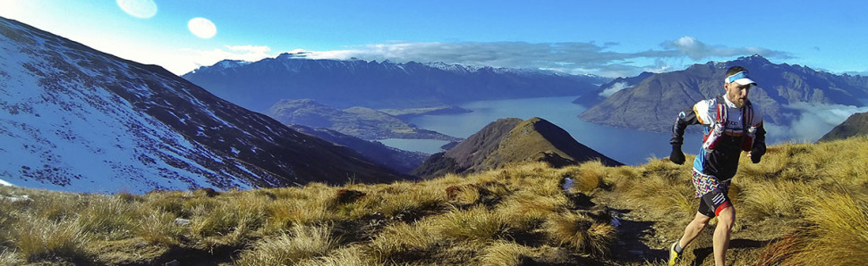
One could argue that New Zealand boasts more killer trails per capita than anywhere else on the planet. And if one did argue that, one would have to say that Queenstown was the capital, so close is it to a plethora of singletrack gold. Thing is, you don’t even have to step far from town centre to be able to tackle a monster mountain run. Matt Judd, usually found on the Gold Coast, nipped over the Tasman to have a play in the hills, Ben Lomond to be precise.
 NEARBY TOWN/CITY: Queenstown (the run starts/finishes in the centre of town)
EXACT LOCATION: Skyline gondola base on Brecon St
TOTAL ROUTE DISTANCE: 16km (give or take)
TOTAL ASCENT/DESCENT: +/-1600m
TIME TO RUN: 2-3hrs for elites. 5-7hrs if you’re taking it easy and enjoying the views.
TYPE OF TRAIL RUN: Out and back with a loop
option to finish
DIFFICULTY: Hard
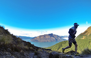
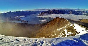
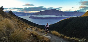
DEFINING CHARACTERISTICS: Native forest, breathtaking views of Lake Wakatipu and the surrounding mountain ranges, beautiful singletrack running
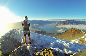
FEATURES OF INTEREST: The run takes in either native beech forest or douglas fir forest down low (depending which way you run), and opens up above the treeline to spectacular lake and mountain views in every direction. Do NOT forget the camera for this one!
FURTHER INFORMATION HERE
MAP HERE
 RUN IT:
There are plenty of variations to how you start/finish this run, but this one takes in a little bit of the lake before taking you up the steep stuff!
1. From the gondola base, head down Brecon St to the lake. You’ll cross several roads during this time but the lake is a pretty easy landmark to find!
2. When you get to the lake turn right onto the wharf keeping the water on your left. Follow this until the wharf ends and a path begins, leading you beside Lake Esplanade heading out of town towards Fernhill. Follow it.
3. You follow the path for 800m or so where you will come to One Mile Roundabout. Here, take the right-most road (there’s a gravel path on the side) which takes you to the One Mile Creek Walk and the old power station.
4. When you get to the old power station take the straight-most option which is signposted. Be careful not to follow the mountain-bike only trails in this area.
 5. The next bit takes a little care navigating as you need to follow the orange trail arrows randomly fixed to trees on the route. It’s not hard to follow, but you need to keep your eyes out for the correct way. The going through here is steep.
6. Continuing up, you eventually find yourself in a clearing (Midway Clearing, but this is not midway for your run!) which you will need to cross, finding the DOC sign to the Ben Lomond Track. Follow the track and after more honest (steep!) work, you’ll find yourself at the edge of the treeline.
7. 300m or so from when you break through the trees, there is a track junction at which you want to continue straight on in the direction of the Ben Lomond saddle. Remember this junction for the return journey. From here it’s onward and upward!
8. Follow the Ben Lomond Track up, being sure to lift your head up and take in the ever-changing, spectacular views of the surrounding region. You will eventually come to a DOC sign at the Saddle indicating the Ben Lomond Summit track to the left (your route) or the Moonlight Track/Arthur’s Point to your right – go left. There’s a chair not far on from here that affords great views of the mountains if you need a sit down.
9. Continue to follow the tramped route, which sees you climb steadily up before taking you around to make your final approach to the summit from the north-west. You made it!
10. Coming back off the summit, re-trace your route back to the saddle and continuing on the Ben Lomond Track towards Queenstown. You will eventually get yourself back to the track junction you first approached that sits about 300m on from the treeline. This time, take the left path which directs you towards the gondola station.
11. Following the signs to the gondola station is easy enough, and once you arrive you can stop for a pit-stop or keep making your journey back to town. From the station, follow the Skyline Access Rd down for 600m or so until you reach the signposted entrance to the Tiki Trail – this is the trail you’ll follow back to the finish.
 12. The Tiki Trail signs guide you all the way back down the steep trails, following the orange tree markers where signs aren’t present. You’ll come to a few mountain bike track junctions along the way but the walking route is well marked. And you’re done!
Note that the track is in an alpine environment up high and can be difficult and often dangerous to navigate in winter conditions (snow and ice!). It always pays to check in at the DOC office in town to find out about track conditions before heading out, and if you can find a local to accompany you – even better!
POST RUN GOODNESS:
Queenstown is perhaps just as well prepared for post-run goodness as it is for the delights of running! For a coffee or quality diner-style breakfast, Joe’s Garage – hidden away on Searle Lane in the middle of town – serves a consistently good brew and hearty sized meals. If you’re chasing a post-run beer, it’s hard to overlook Pub on Wharf – located on Steamer Wharf in the heart of Queenstown – where you’re treated to an affordable-yet-quality menu, a dizzying array of beer choices (*Sassy Red* – thank us later), and you can sit outside and watch the world go by next to the lake. Hard to beat, really.